 catalogsquasars: generalradio continuumreference systemstechniques: interferometric
THE ASTRONOMICAL JOURNAL, 116:516-546, 1998 July
© 1998. The American Astronomical Society. All rights reserved. Printed in U.S.A.
E. F. ARIAS
Observatorio Astronómico de La Plata, Paseo del Bosque s/n, 1900 La Plata, Argentina; and Observatorio Naval Buenos Aires
T. M. EUBANKS AND A. L. FEY
US Naval Observatory, Code EO, 3450 Massachusetts Avenue, NW, Washington, DC 20392-5420
A.-M. GONTIER
Observatoire de Paris, CNRS, URA 1125, 61 Avenue de l'Observatoire, F-75014 Paris, France
C. S. JACOBS AND O. J. SOVERS1
Jet Propulsion Laboratory, California Institute of Technology, 4800 Oak Grove Drive, Pasadena, CA 91109-8099
B. A. ARCHINAL
US Naval Observatory, Code EO, 3450 Massachusetts Avenue, NW, Washington, DC 20392-5420
AND
P. CHARLOT2
Observatoire de Paris, CNRS, URA 1125, 61 Avenue de l'Observatoire, F-75014 Paris, France
A quasi-inertial reference frame is defined based on the radio positions of 212 extragalactic sources distributed over the entire sky. The positional accuracy of these sources is better than about 1 mas in both coordinates. The radio positions are based upon a general solution for all applicable dual-frequency 2.3 and 8.4 GHz Mark III very long baseline interferometry data available through the middle of 1995, consisting of 1.6 million pairs of group delay and phase delay rate observations. Positions and details are also given for an additional 396 objects that either need further observation or are currently unsuitable for the definition of a high-accuracy reference frame. The final orientation of the frame axes has been obtained by a rotation of the positions into the system of the International Celestial Reference System and is consistent with the FK5 J2000.0 optical system, within the limits of the link accuracy. The resulting International Celestial Reference Frame has been adopted by the International Astronomical Union as the fundamental celestial reference frame, replacing the FK5 optical frame as of 1998 January 1.
Key words: astrometrycatalogsquasars: generalradio continuumreference systemstechniques: interferometric
1 Current address: Remote Sensing Analysis Systems, 2235 North Lake Avenue, Altadena, CA 91001.
2 Current address: Observatoire de Bordeaux, CNRS, UMR 5804, B.P. 89, F-33270 Floirac, France.
Celestial reference frames have been used for millennia for purposes of measuring the passage of time, for navigation, and for studying the dynamics of the solar system. In the last century, these frames have become more important to both the study of the dynamics of more distant objects and the study of geophysical phenomena on Earth. Using optical telescopes, reference frames with roughly 0 1 accuracy were produced. With the advent of the technique of very long baseline interferometry (VLBI), rapid improvements in positional accuracy became possible, reaching the milliarcsecond level in the late 1980s. By the mid-1990s, the VLBI technique had improved to such a level that sub-milliarcsecond positional accuracy became possible. The consequent increase in the level of accuracy of celestial reference frames has permitted unprecedented studies of celestial dynamics and geophysical phenomena.
A stellar reference frame is time dependent because stars exhibit detectable motions. For precise astrometric applications, a stellar frame must specify, in addition to positions, an epoch and predicted stellar motions. Imprecise knowledge of proper motion and/or parallax limits the precision of stellar frames at epochs other than the mean epoch of the catalogs. Extragalactic radio sources, on the other hand, are assumed to be very distant (typical redshifts of about 1.0) and thus should exhibit little or no detectable motion. A reference frame defined by the positions of extragalactic radio sources may be said to be a quasi-inertial frame (i.e., a frame nonrotating with respect to an inertial frame) with little or no time dependency.
There exists a large resource of high-accuracy, dual-frequency bandwidth synthesis VLBI data that were acquired from various networks for geodetic and astrometric purposes over a span of more than 15 years and from which various radio source catalogs have been constructed. The goal of the work described here was to create the definitive catalog of extragalactic radio source positions for the International Celestial Reference Frame (ICRF), using the best data and methods available at the time the work was done. This work was the joint cooperative effort of a subgroup of the International Astronomical Union (IAU) Working Group on Reference Frames (WGRF), which was formed expressly for this purpose. Background material on the contribution of VLBI to astrometry and geodesy, a bibliography of previous work, and ancillary information on ICRF sources can be found in Ma & Feissel (1997).
Having gained experience from past efforts, the subgroup has taken an empirical approach in the selection of data, analysis, estimation of errors, and categorization of the final results. The characterization of a radio source, i.e., its position, how it was treated in the analysis, and whether it was suitable for use as a defining object, was derived entirely from the VLBI data and analysis, and not from any other information. This approach leads to a rigorous selection of defining objects and a reliable realization of the ICRF as a set of relative positions oriented to the axes of the International Celestial Reference System (ICRS; Arias et al. 1995). In the context used here, defining refers to those sources with accurate, reliable positions that could be used to orient the ICRF axes.
Several points should be noted at the outset. This realization of the ICRF was considered only one of many, both actual and potential, better than preceding ones, but by no means attaining perfection. The source positions and their characteristics are derived from a particular, although comprehensive, set of data using specific frequencies and networks of stations and covering a certain interval of time. The underlying physics of the target extragalactic radio sources (Marscher 1987) is not as well understood as that of stars, and we can only describe with certainty what the radio sources did during the particular interval of time covered by the observations. It is clear that many extragalactic objects undergo changes in intrinsic structure that can affect their realized positions at levels greater than the precision of their position estimates. From the data set we can see what has happened in the past and surmise, but not predict theoretically, what can be expected in the future. Although extragalactic objects are not as predictable as stars, the benefit of extragalactic objects and VLBI radio astrometry is that the level of astrometric uncertainty is at least 1 order of magnitude better than when using optical measurements of stars. The potential weakness is that the quality of the ICRF so derived cannot easily be given a purely theoretical underpinning.
Because the vast majority of observations were made for geodetic purposes and therefore used the brightest compact radio sources, while the strictly astrometric observations constitute only a small fraction of the total, the information available on the sources from the VLBI data varies enormously. The approach we have taken is to derive the measure of ideal behavior, i.e., invariant position in the celestial frame, from the available data. In some cases, thousands of observations lead to the discovery of statistically significant position variations. For other sources we might only be able to say that the variations in position are not inconsistent with their measurement uncertainties. Fortunately, there is a sufficiently large class of radio sources with more than enough observations and minimal position variations to make the effort worthwhile. In addition, comparisons between independently derived catalogs were used as a consistency check. When significant discrepancies were discovered in such comparisons, the particular sources in question were considered less reliable for use in the ICRF. It was not possible, given the number of observations, to try to explain the small number of discrepant positions.
It was considered essential that the realization of the ICRF be derived from a single analysis, even if imperfect, rather than from a combination catalog made of several VLBI solutions. While various recent catalogs are not inconsistent, except for a few discrepant sources, a combination catalog loses certain information. The operational realization of the ICRF is a set of right ascensions and declinations, but the actual information is the much larger set of relative positions, whose quality is contained in the full covariance matrix. A typical combination catalog does not give access to this information. In addition, there is extensive but not complete overlap of data used in some of the VLBI analyses, and there are differences in modeling between analysis groups. Consequently, understanding the statistics and systematic errors of a combination solution is not straightforward.
VLBI observations for geodesy and astrometry using Mark III compatible systems (Clark et al. 1985) have been conducted since about mid-1979. These observations are made in a bandwidth synthesis mode at standard frequencies of 2.3 GHz (S band) and 8.4 GHz (X band). Dual-frequency observations allow for an accurate calibration of the frequency-dependent propagation delay introduced by the ionosphere, while the multiplicity of channels within a band facilitates the determination of a precise group delay (Rogers 1970). A phase calibration signal is injected into the receiver at both bands at most stations to remove instrumental dispersion and time variations in instrumental delay. Meteorologic information is logged at most stations and is used in tropospheric modeling. Observing sessions are typically of 24 hours' duration, as this period of time is required to recover (separate) parameters for nutation and polar motion.
The VLBI observations used for the ICRF have been obtained primarily by the NASA Crustal Dynamics Project (CDP), now succeeded by the Space Geodesy Project, the Jet Propulsion Laboratory (JPL), which is operated by the California Institute of Technology for NASA, the Geosciences Laboratory (GL), formerly part of the National Geodetic Survey (NGS), which is operated by the National Oceanographic and Atmospheric Administration (NOAA), the US Naval Observatory (USNO), and the US Naval Research Laboratory (NRL).
The CDP programs included several long-term monitoring projects, such as the program to monitor motions between the North American and Pacific plates. In addition, there are numerous short-term projects, too many and too specialized to describe here. The interested reader is referred to Ryan, Ma, & Caprette (1993b). The JPL observations were made primarily for purposes of spacecraft navigation using the Deep Space Network telescopes. Information on aspects of the JPL program can be found in Sovers (1990) and Jacobs & Sovers (1993). Additional information on the GL/NGS observing programs can be found in Robertson et al. (1985, 1993). Information on the USNO Earth orientation observing program can be found in McCarthy & Luzum (1991). The NRL program is described by Johnston et al. (1995).
The geodetic/astrometric VLBI data set has a rich variety of stations and networks. Antennas range from 3 to 100 m in diameter. Baselines range from a few tens of meters to nearly the diameter of Earth. Although extreme baselines contributed very little to the total number of observations and smaller mobile antennas lacked sensitivity to see any but the brightest sources, the entire data set was used (except for sessions entirely between antennas at a single observatory), pooled cooperatively from all the various observing programs. Besides providing the potential for extracting the maximum information, the use of the entire data set includes the widest variation that the network geometry and station size can impose upon the realized ICRF. The ICRF positions and stated uncertainties should then represent realistically how confidently the positions can be used in the future with arbitrary VLBI measurements. The VLBI data for this work were edited following the usual procedures of each contributing group. In the context used here, one observation represents one group delayphase delay rate pair.
While the subgroup had access to several analysis systems and data sets, the solution for the ICRF was made at Goddard Space Flight Center (GSFC) largely for two reasons, one of convenience and one for better modeling. The GSFC system had access to more data and had already implemented an improved tropospheric model. Similar results could have been obtained at other analysis centers such as JPL, but with greater effort. Detailed comparison of the GSFC and the JPL software, described in more detail in § 7.2, gives confidence in the correctness of the mechanical implementation of the VLBI modeling.
The GSFC analysis system (Ryan, Ma, & Vandenberg 1980; Ma et al. 1986; Caprette, Ma, & Ryan 1990; Ryan et al. 1993b) consists of the astrometric and geodetic VLBI reduction software CALC, SOLVE, and GLOBL. The data analysis methods using the GSFC system are covered in detail by Ma et al. (1986) and will be described only briefly here. CALC calculates the observation equations including most partial derivatives and contains most of the physical models of the reduction process, generally following the International Earth Rotation Service (IERS) Standards and Conventions (McCarthy 1992, 1996). The IAU definitions of precession (Lieske et al. 1977), sidereal time (Aoki et al. 1982), and nutation (Wahr 1981; Seidelmann 1982) were adopted as the underlying models. SOLVE uses the output of CALC, along with some additional modeling, to perform a least-squares solution to estimate parameters such as source or station positions and Earth orientation parameters. GLOBL is a noninteractive way of running SOLVE so that data from different experiments can be combined, allowing some parameters (e.g., source positions) to be estimated from a combination of many data sets. To obtain a solution, the individual data sets are combined sequentially using "arc" parameter elimination (Ma et al. 1990). All solutions give weighted least-squares estimates for parameters. Time-invariant or "global" parameters, i.e., parameters dependent on all data sets, are carried from step to step, resulting in a single estimate derived from the combined data of all experiments in the solution. Depending on the problem at hand, these global parameters may include station positions, station velocities, source positions, source velocities (proper motions), nutation series coefficients, the precession constant, Love numbers for the solid Earth tides, and the relativistic gamma factor. Local or "arc" parameters depend only on the data from an individual experiment and are estimated separately for each epoch of observation. Arc parameters include those for the station clocks and atmospheres, Earth's orientation, and nutation offsets in obliquity and longitude. Station positions and source positions can also be arc parameters if the solution is to follow changes over time.
The astrometric positions given in this paper result from a particular choice of analysis configuration as described in following sections.
As suggested previously, the observed sources can be characterized along several lines. The most important are variations in position seen in the data and the number of observations per source. The underlying conceptual basis of this type of realization of the celestial reference frame is that positions are invariant with time. Therefore, the first task was to ensure that this condition was not significantly violated. A series of solutions was made. In each solution, the positions of all sources except for a small test set were estimated as time-invariant "global" parameters. The positions of the test sources were treated as "arc" parameters, with a position estimated for each day the source was observed. Each source was treated as a test source in some solution. The complete set of source positions as functions of time was then analyzed to determine which sources had statistically significant variations in their positions. Sources were rejected if the magnitude of the weighted rms of the source position variations from one epoch to the next exceeded 0.5 mas or 3  (based on the position formal errors). In addition, in another solution proper motion was estimated as a "global" parameter for all sources with sufficient data (two or more observing sessions). For sources with sufficient data to derive statistically significant apparent linear motions, a source was considered problematic if the apparent motion exceeded 50
  as yr-1 and was greater than 3 times the formal error. Since these two classes of sources showed undesirably large position variation, they were treated differently from other sources in the final analysis. To accommodate their position variations without deforming the geometry of the remaining sources, the positions of these sources were adjusted separately for each session in which they were observed. A total of 102 of 608 observed sources were found to have unstable positions by these criteria.
The configuration of the ICRF analysis was developed as a balance between competing goals: the most data and the least systematic error; the best models and available options; the largest number of useful estimated parameters and computer speed, etc. As improvements occur in the future, the balance may shift and the results should be better still.
The most important configuration choices are related to data selection and modeling. To extract the most information from the data, both the group delay and phase delay rate observables were used. Only observations above 6° elevation were included in the solution, because of inadequacies in modeling the troposphere at lower elevations. There may also have been additional systematic error introduced into the solution because of poor modeling of phase delay rate variations induced by tropospheric fluctuations. The troposphere was modeled using the MTT mapping function (Herring 1992), estimating the zenith troposphere effects in the form of 1 hr piecewise linear continuous functions with constraints on the size of variations. While shorter time intervals have been shown to produce better geodetic results, they were not used in this analysis because of computer speed limitations. Time-variable gradients in the troposphere were also estimated (see § 6.3). The effect of tropospheric gradients on the source coordinates is described in § 7.3. Because it was not available in the GSFC analysis system, no atmospheric structure information (Treuhaft & Lanyi 1987) was used to weight the least-squares fit.
The primary geodetic parameters, the station positions, were estimated separately for each session. In this way, any nonlinear motion of the stations (e.g., unmodeled tectonic motion, long-term antenna motion, or earthquake displacements) does not affect the integrity of the invariant source positions. The relative source positions derived from a single 24 hr session are not distorted by forcing the station positions for that day to conform exactly to a linear model. Station motions within a day, from solid Earth tides and ocean loading, were derived from unadjusted a priori models (McCarthy 1992).
The weighting of the data followed the usual GSFC practice. For each session, a pair of added noise values was computed for delays and delay rates that caused the reduced 
 (the 2 per degree of freedom) to be close to unity when added to the variance of the observations derived from the correlation and fringe-finding process, as well as the calibration of the ionosphere. Other modifications of the observational errors, such as elevation-dependent and source-dependent noise, were not used.
The unadjusted a priori models for geophysical effects, precession, and nutation generally followed the IERS Standards (1992) (McCarthy 1992). The VLBI theoretical model for the geometric portion of the delay (including relativistic effects) was the so-called consensus model given in the IERS Conventions (1996) (McCarthy 1996).
As mentioned previously, parameters were estimated using arc-parameter elimination (Ma et al. 1990), which is an incremental least-squares method that can accommodate large numbers of parameters if they are associated only with particular data intervals, or "arcs." In the ICRF analysis, several classes of parameters were adjusted. For each observing session, the adjusted arc parameters included positions of sources with identified excessive apparent motion or random variation; two celestial pole offsets to account for errors in the standard precession/nutation models; positions of the stations; the rate of UT1 relative to a good a priori time series; 1 hr troposphere parameters, described above; tropospheric gradients in the east-west and north-south directions, linear in time; quadratic clock polynomials for the gross clock behavior; 1 hr clock parameters similar to the 1 hr troposphere parameters; and necessary nuisance parameters, such as clock jumps and baseline clock offsets (i.e., separate bias parameters for each VLBI baseline to accommodate small, constant, baseline-dependent instrumental and correlator errors).
The remaining parameters were adjusted as invariant quantities from the entire data set. These "global" parameters included invariant source positions, geometric axis offsets for all fixed antennas, and 252 parameters for Earth rotation variations in the diurnal and semidiurnal bands caused by ocean tides.
The axis offset and ocean tide Earth rotation adjustments were all small and consistent with geodetic solutions, but the estimates were included to eliminate any influence on the source positions and to avoid falsely optimistic source position covariances that would occur if the axis offsets and tide parameters were assumed to be perfectly known.
After completing a series of test solutions to refine various aspects of the analysis, a final solution was run in the fall of 1995 that included 1.6 million pairs of group delays and phase delay rates obtained from observations spanning the time period from 1979 August through 1995 July. The postfit weighted rms residuals were 32.6 ps for delay and 104.2 fs s-1 for rate, with a reduced of 1.08. There were 1305 global parameters, about 650,000 arc parameters, and over 2.5 million degrees of freedom.
Several results are obtained from the final least-squares solution, designated "WGRF" for the following discussions. Of primary importance is the set of invariant source positions and their formal uncertainties. The full covariance matrix of these source positions is another important result, although rather massive for everyday use. The time series of positions for "arc" sources from the individual session estimates show the level and character of their position variations. For these sources, an additional step was taken to calculate the weighted mean positions and weighted rms scatter as a measure of error. In addition, the observation and session counts for each source give some indication of the usefulness of a source.
Some of the auxiliary model parameters that were determined in the course of generating the celestial reference frame are of interest for their own sake. Two sets of such parameters fall into categories that are related to the ICRF orientation and stability. The session-by-session nutation angle offsets from the a priori precession and nutation models in ecliptic longitude, 
 , and obliquity,
  , contain information concerning inadequacies of the present IAU models of precession and nutation, and they thereby fix the orientation of the principal axis of the ICRS at J2000.0. This is found to be substantially different from the location of the standard IAU celestial pole at J2000.0.
Likewise, the positions of "arc" sources can be used as indicators of the time variability of their intrinsic structure. In addition to serving as indicators of the suitability of a source as a defining fiducial point in the ICRF, the time dependence of such source positions places limits on the stability of the frame over decadal time spans.
A third set of parameters of interest are those for modeling tropospheric delay gradients at the observing stations. The solution giving rise to the ICRF catalog is one of the first large-scale estimates of such gradients. As discussed in § 7.3, accounting for these gradients is essential in removing sizable declination systematic errors.
The following three subsections consider the above parameter categories in turn. Conditions of their estimation in the ICRF solutions are discussed in some detail, as is their relevance to the accuracy and stability of the ICRF on the one hand and astrometric/geodetic modeling on the other.
In order to achieve the best accuracy in the VLBI analysis leading to the ICRF, short-term variations of the celestial ephemeris pole need to be taken into account. As mentioned above, this was achieved by estimating corrections to the nutations in longitude, , and obliquity, , for each VLBI observing session. The time series of these estimated nutation angles are thus an integral part of the modeling for the ICRF. To preserve the highest accuracy, e.g., in calculating source coordinates of date, these corrections should be part of the model. Rather than interpolating this nonuniform time series, it is more convenient to generate corrections to the IAU a priori precession and nutation models by a least-squares fit to the series of nutation angles.
Figure 1 shows the time series of nutation corrections relative to the 1980 IAU model. Each point is plotted with its formal uncertainty from the VLBI solution giving rise to the ICRF source catalog. The curves show analytic functions fitted to the VLBI results in a postprocessing step. Approximately 2400 pairs of nutation angle corrections were fitted to a model that includes a bias, linear drift, and terms both in and out of phase with the 1980 IAU 18 yr, 9 yr, annual, semiannual, 121 day, and 14 day nutation terms. Points with formal errors that exceed 5 mas were omitted from the plot in order to provide an uncluttered graphic presentation. The omitted points amount to about 5% of the available points and do not affect the results significantly, because of their low weights. The resulting time rates of longitude (lunisolar precession) and obliquity are -2.84 ± 0.04 and -0.33 ± 0.02 mas yr-1, respectively. These values are in reasonable agreement with recent published results (e.g., Charlot et al. 1995). Nutation amplitudes of components in phase with the basic 1980 IAU series are likewise in reasonable agreement with previous results: 18 yr (, ) in milliarcseconds (-6.1 ± 0.2, 2.7 ± 0.1), 9 yr (0.9 ± 0.04, -0.2 ± 0.02), annual (5.1 ± 0.02, 2.2 ± 0.01), semiannual (1.6, -0.6), and 14 day (-0.3, 0.2). The formal uncertainties of the corrections for the last two periods are all 0.01 mas, while the 121 day corrections are not significant at the 0.1 mas level.
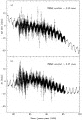 | FIG. 1.Time series of nutation corrections relative to the 1980 IAU model for (a) sin and (b) generated from the VLBI solution giving rise to the ICRF source catalog. |
The reduced value of 3.2 and the scatter about the fit are roughly consistent with the inflation of ICRF source coordinate formal uncertainties, discussed in § 9. Although the ICRS was constructed to be consistent with the FK5 pole of J2000.0, Figure 1 clearly shows that there is a difference between the mean J2000.0 pole and the ICRF pole of  19 mas in sin and 4 mas in . However, this difference is within the error of the stellar realization.
Some idea of the long-term stability of the ICRF can be gained from a consideration of test solutions in which the position of each source with sufficient data is allowed to vary linearly, subject to a global constraint of no net rotation. These solutions thus provide absolute proper motions relative to the entire ensemble of ICRF sources. Figure 2 shows the smoothed time evolution of the astrometric positions in  cos
cos  for three well-observed sources of different astrometric quality. The plotted positions represent 45 day moving averages, with no overlap, of the raw "arc" positions for these sources. The data have been averaged for clarity of presentation.
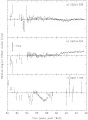 | FIG. 2.Time evolution of the astrometric position in cos for the extragalactic sources (a) 0552+398 (DA 193), (b) 0923+392 (4C 39.25), and (c) 2251+158 (3C 454.3). Tick marks on the vertical axis are spaced 1 mas apart. |
Figure 2a shows the time evolution of the right ascension of 0552+398 (DA 193), the most frequently observed source in the ICRF. A weighted least-squares fit to the data suggests that there is no statistically significant, long-term linear motion in the right ascension of this source. Figure 2b shows the time evolution of the right ascension of 0923+392 (4C 39.25). A weighted least-squares fit shows that, for this source, there is a statistically significant long-term motion. This motion is not seen in other angularly nearby ICRF sources, and it is interpreted as a change in the brightness distribution of this particular source. The observed angular rate of 59.8 ± 2.2 as yr-1 for 0923+392 translates into an apparent transverse velocity of  1.3 times the speed of light, strong evidence that this motion is due to intrinsic source structure changes (Fey, Eubanks, & Kingham 1997). The positions of both 0552+398 and 0923+392 have weighted rms residual scatters of about 0.20.3 mas about the best-fit linear model, indicating that the short-term stability of the ICRF is at approximately the 0.3 mas level, or better.
Figure 2c shows the time evolution of the right ascension of 2251+158 (3C 454.3). The data for this source are not well represented by any linear trend over periods much longer than a few months. The scatter of the residuals of the right ascension data about a straight-line fit is very much larger than can be explained by the formal errors. Clearly, the position of this source cannot be repeated to much better than about 1 mas, which indicates the limitations involved in using the positions of such sources as fiducial marks.
Tropospheric propagation delay, which has been and continues to be one of the principal errors encountered in the analysis of VLBI astrometric and geodetic data, varies as a function of elevation and azimuth of the VLBI observation. Continuing improvements in the mapping functions that describe the elevation dependence of the tropospheric delay (Davis et al. 1985; Herring 1992; Niell 1996) have been successful in reducing systematic and random errors in estimated geodetic and astrometric parameters. In test solutions for the current work, no significant differences were found between the astrometric results using the MTT (Herring 1992) and the Niell (Niell 1996) mapping functions. Azimuthal asymmetries in the tropospheric delay, i.e., tropospheric gradients (Chen & Herring 1997), have been observed (Davis et al. 1993), and geodetic precision is improved when gradient parameters are estimated in the VLBI analysis (Herring 1992; MacMillan 1995). The systematic effect of tropospheric gradients on source positions is described in § 7.3. The estimated gradient parameters show a mean north-south asymmetry in the troposphere, as well as seasonal variations that depend on specific stations. Spatial variation in east-west gradients is about one-third the spatial variation in north-south gradients, while long-term mean east-west gradients are close to zero. The mean north-south gradient values are latitude dependent and are consistent with the general increase of pressure, temperature, water vapor, and tropopause height toward the equator. The nearly zero mean east-west gradient values are consistent with the general east-west progression of large-scale weather systems.
Given the very large number of observations for some sources, the error contribution from observational noise is very small and not a meaningful measure of uncertainty. It is therefore necessary to consider several other effects in order to assign realistic errors. One consideration is the statistical validity of the formal errors. Another is the cumulative influence of all modeling errors and editing decisions. Yet another is the magnitude of specific, identifiable systematic errors that could have distorted the results.
The VLBI data used here have also been analyzed for geodetic purposes. Extensive tests of the geodetic results (Ryan et al. 1993a) indicate that a multiplicative factor of 1.5 is appropriate to scale the formal errors of estimated parameters, such as station positions, in order to represent their actual variation over subsets of data. Because of the relative paucity of data for many sources and the large amount of computer time required, a similar analysis was not undertaken for the astrometric results. Nonetheless, preliminary work shows that it is necessary to apply a similar scaling factor to the formal errors of the source positions. It should be noted that this scaling of formal errors is not intended to represent the degradation of source position repeatability in those sources with variable intrinsic structure. We have attempted to handle intrinsic-structure effects by stringently removing such sources from the defining list.
The cumulative effect of modeling errors and data editing can be examined in detail by comparison of radio source catalogs derived from independent analyses using different data and/or different analysis software. Intercomparison of different radio source catalogs addresses the problem of incorrect modeling and consequent systematic errors. Aspects that can be probed by catalog comparisons include (1) agreement between independent data sets, (2) processing differences at different analysis centers, (3) agreement between subsets of the same database, and (4) intentional perturbations of the modeling.
We have made a number of such comparisons between the WGRF catalog that was derived from all available VLBI data, associated catalogs derived from the same database that were created for test purposes, and existing radio source catalogs. Existing catalogs include the 1994 and 1995 IERS realizations of the celestial reference frame (hereafter IERS94 and IERS95) and the radio-optical reference frame of Johnston et al. (1995) (hereafter RORF). Comparing WGRF with the latter indicates the magnitude of coordinate discrepancies to be expected between global catalogs and, to some extent, points 2 and 3 as well. Points 1 and 2 were tested by comparisons with two catalogs based on independent data and analyzed with independent software. The two catalogs are denoted "GSFC" and "JPL" and are based, respectively, on data collected at GSFC and at JPL using independent VLBI networks. The two independent data sets were analyzed respectively at GSFC using CALC/SOLVE and at JPL using the JPL MODEST software package. Finally, point 4 was tested with three additional catalogs: WGRFna, WGRFel, and WGRFng. In the solution used to produce the WGRFna catalog, all source coordinates were treated as global parameters (i.e., no sources were arc parameters). For the WGRFel catalog, the threshold for eliminating lower elevation observations was raised from 6° to 7°. Finally, for the WGRFng catalog, no tropospheric gradient parameters were estimated in the solution. For these last three catalogs, all other parameterization of the solutions was identical to that of the WGRF solution.
Assessment of catalog comparisons relies on several measures of the overall alignment and agreement of the coordinates. Table 1 shows such results for the nine pairs of catalogs in the comparisons. The quantities A1, A2, and A3 are the rotation angles about Cartesian axes to bring each pair of catalogs into best coincidence; the reduced values are calculated from position differences after the rotation is applied to one catalog of the pair. Off-diagonal covariances are neglected in all comparisons. Agreements in cos and between catalogs are indicated by rms differences about the mean; another measure is a similar quantity for arc lengths between all pairs of sources. Potentially significant internal trends in the variation of coordinate differences with and are assessed by fitting linear models to all four combinations versus , and versus , . The largest variations of these fits over the celestial sphere, Dmax, as well as their significance in units of the formal uncertainty of the slope, Dmax/, are reported in the last two columns of Table 1. With two exceptions, they are all in versus ; the exceptions are versus for IERS95 versus IERS94 and versus for WGRF versus WGRFna.
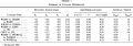 | TABLE 1 SUMMARY OF CATALOG DIFFERENCES |
Table 1 shows that all the tested catalogs are well aligned: rotational offsets do not exceed 0.5 mas around any of the three axes. Systematic errors appear to be present, however, as indicated by the reduced values of between 2 and 3 for many comparisons after the removal of the rotational offsets. Note that the rotations and the reduced values are considerably smaller for the last three catalog pairs, which involve only minor modeling variations but are derived from the same data set. This result also holds true for the rms differences and trends: these remain below 0.3 mas and 0.2 mas per 100°, respectively. Only the inclusion of tropospheric gradients in the modeling has an appreciable impact. This is discussed in § 7.3.
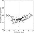
The results are significantly different, however, for the first six catalog pairs. Differences are as large as 0.4 mas for coordinates and 0.6 mas for arc lengths, with trends reaching 0.7 mas per 100° with 15 apparent significance. The differences in coordinates are largest for the GSFC versus JPL comparison. The individual differences between these two catalogs are shown in Figure 3.
 | FIG. 3.Vector differences between two catalogs based on independent data and analyzed with independent software. The two data sets were analyzed, respectively, at GSFC using their CALC/SOLVE software package and at JPL using their MODEST software package. A three-dimensional rotation between the two catalogs (listed in Table 1) has been removed. The lengths of the vectors represent the magnitude of the difference of the positions (as indicated by the key), while the orientations of the vectors represent the direction in which the positions differ on the sky. The data and the analysis used to derive the positions for these two catalogs are completely independent. The large differences in the southern hemisphere arise from limitations in the observing geometry of the JPL data set. |
It should be noted that the significance of the systematic trends in coordinate differences is exaggerated in the results of Table 1. As noted above, these values were calculated without using off-diagonal covariances. When correlations among all source coordinates are taken into account, the significance of such trends decreases substantially. As an example, the fairly large deviations in declination visible for southern hemisphere sources in Figure 3 are not as significant as they appear, as these declination differences are correlated. This is an indication that the quality of the source coordinates over some limited region of the sky is considerably better than their coherence over the entire celestial sphere. The most likely source of such behavior is in the correlations among observations introduced by limitations of observing networks and schedules.
Other considerations of catalog comparisons are the level of agreement one would expect from using independent analysis software and the bias introduced by different analyst choices in editing the raw data. To address the influence of differences in software, a program of model comparison was undertaken. Three software packages (GSFC's CALC, used to generate the WGRF catalog, JPL's MODEST, and the GLORIA package of the Observatoire de Paris) were compared in detail for all observables in one 24 hr VLBI observing session. Because of software limitations, not all model components were compared, most notably the axis offsets of antennas with nonintersecting axes. Furthermore, some model components, such as different tropospheric mapping functions, were compared only within the same software package. After considerable effort to match modeling options between the different software packages, the weighted rms delay and delay rate observables output by each package were found to be in agreement to within 1 ps and 1 fs s-1, respectively. Effects on source positions would thus be limited to errors on the order of 1 ps 0.3 mm, which on a 10,000 km baseline is 0.005 mas. This is approximately a factor of 60 lower than some of the systematic problems exposed in Table 1.
Having isolated modeling differences, we next built catalogs using an identical subset of the data but analyzed using different software (CALC, MODEST) and analyst choices. The rotation angles between the resulting catalogs were A1 = 0.14 ± 0.03 mas, A2 = -0.01 ± 0.02 mas, and A3 = 0.00 ± 0.02 mas. The bias of the coordinate means in cos and was 0.01 and 0.02 mas, respectively. The weighted rms difference between the two catalogs was 0.15 and 0.21 mas, respectively, in cos and .
In summary, analyst choices may introduce scatter of a little less than 1 formal error (which is 0.18 and 0.29 mas in the median for cos and , respectively) but do not significantly bias the coordinate means. The closeness of the model comparisons indicates that the discrepancies between source catalogs are determined by other factors. The model comparisons indicate that one can have very high confidence in the correctness of the model implementations.
The gradients in the troposphere, estimated from the data, illustrate how a systematic effect on the source positions can arise from a discrete change in the analysis. Figure 4 shows the differences between source declinations from analyses with and without correction for estimated tropospheric gradients. The effect is much larger than the formal errors and is caused by the greater tropospheric thickness nearer the equator (MacMillan & Ma 1997). While the effect is not large in absolute terms, it is systematic and would distort the celestial reference frame if ignored. Note that the tests used for the catalog comparisons in § 7.2 also detected this nonlinear distortion.
 | FIG. 4.Effect of tropospheric gradients on declinations as a function of declination. The sense is declinations with gradients estimated minus declinations without gradients estimated. Points with formal errors greater than 2 mas have been omitted for clarity. |
Many extragalactic sources display structure on milliarcsecond scales for the strong radio emission associated with their compact cores. Temporal variations of the intrinsic structure of these objects may result in apparent motion when observations are made at several epochs. Until recently, the intrinsic structure of the majority of the sources has been mostly unknown. The surveys of Fey, Clegg, & Fomalont (1996) and Fey & Charlot (1997) show that most sources, when examined in detail, exhibit spatial structure on milliarcsecond scales. Their results show that the variation of intrinsic structure from source to source can be quite extreme, ranging from relatively compact naked-core objects, to compact double sources, to complex core-jet objects. The situation is exacerbated by the fact that compact extragalactic radio sources are known to have variable intensity and to have frequency- and time-dependent intrinsic structure. Consequently, unknown and/or unmodeled source structure effects may be introduced into the astrometric solution.
Charlot (1990) has modeled the effects of radio source structure on measured VLBI group delays and delay rates. Results of this modeling suggest that these effects can be significant for extended sources (typically at a level of 100 ps). Fey & Charlot (1997) calculated structure corrections based on the Charlot analysis using source models derived from Very Long Baseline Array observations of 169 extragalactic sources. Results of these calculations show that intrinsic-structure contributions to the measured bandwidth synthesis delay are significant, ranging from maximum corrections of only a few picoseconds for the most compact sources to maximum corrections of several nanoseconds for the most extended sources. Fey & Charlot (1997) found a correlation between the compactness of the sources and their position formal uncertainties indicating that the more extended sources have larger position formal errors. They also define a source "structure index" based on the median of the calculated structure corrections. They suggest that this index can be used as an estimate of the astrometric quality of the sources as follows: Sources with an X-band structure index of 1 may be considered very good astrometric sources. Sources with an X-band index of 2 may be considered good sources, while sources with an X-band index of 3 should be considered marginal (and should only be used with caution). Finally, sources with an X-band index of 4 should not be used at all for astrometric work. In addition, sources should have an S-band structure index of either 1 or 2, with a preferred value of 1, regardless of the value of their X-band structure index.
Shown in Figure 5 are contour plots of the radio emission at 3.6 cm wavelength for four sources (0138-097, 0108+388, 0544+273, and 2201+315) observed by Fey & Charlot (1997). These sources are representative of each structure index class. The X-band structure index of these sources is indicated in each panel. The S-band structure index of each source is 1 with the exception of 0108+388, which has an S-band structure index of 2. Only the two sources 0544+273 (structure index 1) and 0138-097 (structure index 2) are ICRF defining sources (see § 10). Also shown in Figure 5 are the corresponding structure-effect maps. These indicate the corrections to the VLBI delay observable as a function of interferometer resolution. The mean, rms, median, and maximum values of the structure corrections calculated by Fey & Charlot (1997) for these sources are also indicated in each panel.
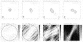 | FIG. 5.Top: Contour plots of the radio emission at 3.6 cm wavelength for the four sources (a) 0544+273, (b) 0138-097, (c) 2201+315, and (d) 0108+388. Tick marks are spaced 1 mas apart. Contour intervals are spaced by a factor of 2 in intensity starting at (a) 2.21, (b) 1.67, (c) 2.38, and (d) 2.41 mJy beam-1. The X-band structure index is indicated in each panel. These sources are representative of each structure index class. Bottom: Gray-scale plots showing the magnitude of the structure correction (absolute value) induced in the bandwidth synthesis delay by the extended radio emission at the X band for the same four sources. The structure correction is plotted as a function of the length and orientation of the VLBI baseline projected onto the sky, expressed in units of millions of wavelengths (u-v plane coordinates). The gray scale is identical in each panel and ranges from 0 to 100 ps. All structure corrections greater than 100 ps are plotted as black. The circle drawn in these plots has a radius equal to one Earth diameter, corresponding to the longest baselines that can be theoretically observed with Earth-based VLBI. The mean, rms, median, and maximum values of the structure corrections for all baselines contained within this circle are indicated in each panel. The structure index classes defined by Fey & Charlot (1997) are based on the median. |
A caveat on the use of the structure index is worth noting at this point. The projected VLBI baselines at which structure effects will be most prominent also tend to be very near minima in the visibility function (Charlot 1990). This fact reduces the chances of a VLBI detection, and in the cases where an extended source is detected (with low amplitude and low signal-to-noise ratio), the resulting astrometric solution formal errors will be increased. The end result is that the low visibility amplitude and low signal-to-noise ratio will increase the odds that an observation of an extended source is edited out or is down-weighted in the solution. In this sense, astrometric VLBI analysis partially compensates for structure effects. Consequently, the structure index should not be the sole method for classifying sources for astrometric suitability but should be given at least equal consideration with other source selection criteria (cf. Fey & Charlot 1997).
The variations in source positions discussed in § 6.2 were not comprehensively analyzed to determine the underlying causes. The position variations for some sources show clear correlations with changes in intrinsic structure, and to some extent, the position changes can be derived from the structure, but there is no strong evidence of any regularly repeated behavior. There are 366 sources in the VLBI database with sufficient observations to estimate meaningful proper motions, with 116 of these sources having proper-motion formal errors less than 50 as yr-1. Of these sources, only 26 have proper-motion estimates statistically different from zero (at the 99.9% confidence level). Since the statistically significant proper motions typically translate into transverse apparent velocities of 35 times the speed of light, these motions are presumably caused by source structure changes related to the superluminal motions (i.e., motion perpendicular to the line of sight with an apparent linear velocity in excess of the speed of light) observed in components ejected from the cores of many of these same extragalactic radio sources (Vermeulen & Cohen 1994). In a few cases (e.g., Charlot 1994; Fey et al. 1997), the observed absolute motions have been related to specific components observed in source images.
From a consideration of error sources such as described in § 7, it was concluded that a realistic error estimate for the invariant source positions could be made by inflating the formal errors by a factor of 1.5 followed by a root sum square increase of 0.25 mas. For the most frequently observed sources, the 0.25 mas is the dominant error. The errors of the "arc" sources were also increased by 0.25 mas in quadrature.
The method adopted at the IERS until 1995 for the realization of the extragalactic reference frame consisted of combining individual VLBI frames by applying an algorithm based on catalog comparison. The positional uncertainties derived from the combination reflected the disagreement between individual analyses.
A similar solution was performed for this work in order to study the question of whether adopting a "unique calibration law" for all sources would eliminate or at least minimize systematic errors. Individual VLBI frames submitted by GSFC, JPL, NOAA, and USNO to the IERS in 1994 (see Charlot 1995) were included in a combination solution. The solution included parameters describing the difference between the frames (three rotation angles, drifts in right ascension and declination as functions of declination, and a bias in declination). A comparison of the "inflated" WGRF uncertainties with those obtained from the catalog combination showed that there were still a nonnegligible number of sources whose inflated uncertainties were smaller than those resulting from the comparison of parallel analyses with a deformation correction model. For these sources, the uncertainty for each coordinate was set to be the larger of the inflated or the comparison value.
Because of different observing histories and astrometric suitability, the source positions estimated from the VLBI data analysis are of varying quality. In order to define the axes of the ICRF as accurately as possible, only the highest quality positions can be used for determining or "defining" the orientation of the ICRF. The remaining, or "nondefining," sources, derived from the same solution as that of the defining sources, are included primarily to densify the frame.
To be most useful in defining the ICRF, a source should ideally show no variation of position in the data set, have sufficient data to support the absence of variation, and not have shown unexplained differences in position between realizations of equivalent validity. Several quality levels can be established for each of the 608 sources in the WGRF catalog. These levels are based on one of three sets of criteria: (1) quality of data and observation history, (2) consistency of coordinates derived from subsets of data, and (3) repercussions of source structure.
To qualify for the list of sources that could be used to orient the WGRF catalog with respect to the IERS celestial reference system, a source must meet the criteria in all three categories. An attempt to quantify the criteria follows. In category 1, a source is disqualified if it has fewer than 20 observations or if the observations span less than 2 yr. Each of the individual formal coordinate uncertainties cos and from the least-squares solution (before "inflation" of the uncertainties as described in § 9) must also be smaller than 1 mas. In category 2, a source may be disqualified on the basis of the magnitude and significance of its coordinate differences in several pairwise catalog comparisons. After application of a global three-dimensional rotation to place each pair of catalogs in best coincidence, if the coordinate differences exceed 0.5 mas or 3 in either coordinate, the source is disqualified. In category 3, three separate tests for structure effects must be satisfied. First, the source must have shown enough positional stability so as to not qualify for "arc" position estimation. Second, the structure index at the X band, when available, must be 1 or 2 (median absolute value structure correction smaller than 10 ps). Unfortunately, at the time of the ICRF analysis, these values were only available for the 42 sources imaged by Fey et al. (1996). While the fraction of sources with available images was rather small (42 out of 608), the corresponding fraction of VLBI observations involving these sources is respectable (55%). Finally, in subsidiary solutions that estimated time rates of change of right ascension and declination, the significance of any estimated motions must not exceed 3 .
The sources then fall into three categories: 212 defining sources that fail none of the above criteria, 294 candidate sources that fail some or all of the criteria, and 102 "other" sources with identified excessive position variation, either linear or random. Some candidate sources have insufficient observations or duration of observation for reliable designation as defining sources, while others with many observations may have larger than expected differences in position between catalogs. Many frequently observed sources fail to be included in the defining category. In fact, the majority of sources with more than 20,000 observations do not pass at least one of the chosen criteria. This is most likely a reflection of the stringency of the criteria for eligibility as a defining source. Candidate sources potentially could be designated defining sources in future realizations of the ICRF as more data become available or analysis improves. The third category, of "other" sources, includes sources that may be useful for purposes such as radio-optical frame ties. While only the defining sources have a formal role in the ICRF, the positions of all sources are consistent with the ICRF. The VLBI database also included several sources with inadequate data to estimate useful positions, as well as several radio stars. These few sources have been excluded from the analysis of this paper and will not be considered further.
Well after the defining source list was finalized, additional sources were imaged and their structure indexes computed. Four sources (0153+744, 0518+165, 0831+557, and 1532+016) with stable positions and already included in the best category were found to have an X-band structure index of 4. The structures of 0153+744, 0518+165, and 0831+557, however, appear to be stable over time.
The VLBI analysis for the WGRF catalog described above provided accurate relative positions and an overall orientation extremely close to that of the ICRS (Arias et al. 1995). However, the solution was not designed to obtain results directly on the ICRS. The final stage in the ICRF realization was the rigid rotation of the relative positions to the ICRS, maintained by the IERS. The WGRF catalog was aligned to the ICRS by rotating it onto the latest available realization of the IERS celestial reference frame, IERS95.
Radio source coordinates in IERS95 were obtained by combining individual extragalactic reference frames submitted to the IERS in 1995. The coordinates adopted for a set of 236 defining sources aligned the axes of IERS95 to the ICRS.
Because of the model adopted in the compilation of IERS95, the frame was affected by deformations coming from the individual contributed catalogs. The improvements in the models and procedures applied in the WGRF solution resulted in a frame less corrupted by deformations but slightly misoriented with respect to IERS95. In the procedure applied to rotate the WGRF positions to the IERS frame, care was taken not to transfer the deformations of the latter to the former.
The algorithm used to put the WGRF coordinates into the ICRS was based on a catalog comparison of common sources (Arias, Feissel, & Lestrade 1988). However, not all common sources contributed to the calculation of the rotation angles between the two frames. From the 212 WGRF defining sources, only 117 were defining sources in IERS95. These sources are well distributed in the northern hemisphere but rather sparse in the southern hemisphere. To obtain a better distribution of sources on the sky, an additional 16 IERS95 defining sources not in the WGRF defining list but with rather high quality were included, resulting in 133 common objects for comparison.
The ICRF extragalactic frame was obtained by putting the radio source coordinates from the WGRF solution on the ICRS via comparison with IERS95. Relative orientation and deformation parameters to transform IERS95 to WGRF are listed in Table 2. The parameters A1, A2, and A3 are the rotation angles between axes of the frames; D and D are the linear trends in right ascension and declination, respectively, as a function of declination; and B is a declination bias parameter (Feissel & Essaifi 1994, p. II-25). All of these parameters have been adjusted on the basis of the 133 common defining sources. The quantities wrms cos and wrms are the weighted rms residuals in cos and , respectively.
 | TABLE 2 ALIGNMENT OF THE ICRF AXES WITH THE ICRS |
Table 2 shows that the axes of both frames are aligned to better than 0.02 mas. The deformation of IERS95 relative to WGRF is represented mainly by a bias of the principal plane. To test the stability of the axes of the system, we estimated the relative orientation between WGRF and IERS95 on the basis of different subsets of sources. The scatter of the rotation parameters obtained in the different comparisons indicates that the axes are stable to within 0.02 mas.
The positions, errors, C- (the correlations between right ascension and declination), and observation and session statistics of the ICRF defining sources are given in Table 3. Similar information for the candidate and "other" sources is given in Tables 4 and 5, respectively. The X-band and S-band structure indexes are given where available, and Hipparcos link sources (see Kovalevsky et al. 1997) are also identified. Ancillary information, such as source type, source redshift, and VLBI images, can be found in Ma & Feissel (1997).3
 | TABLE 3 COORDINATES OF THE 212 DEFINING SOURCES IN THE ICRF |
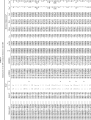 | TABLE 4 COORDINATES OF THE 294 CANDIDATE SOURCES IN THE ICRF |
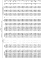 | TABLE 5 COORDINATES OF THE 102 "OTHER" SOURCES IN THE ICRF |
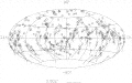
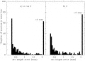
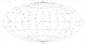
Figures 6, 7, 8, and 9 show the distribution of "inflated" position errors for the sources by category. Figures 10, 11, 12, and 13 show the distributions of the objects on the sky for the same four categories. From these figures it can be seen that there is a moderately even distribution of all sources over the sky but that the southern hemisphere is deficient in defining sources. This is caused by the small number of VLBI stations in the Southern Hemisphere and by limited observing programs. While all sources are given ICRF designations, it should be emphasized that the quality and intended use of the three categories are quite different. The best astrometric quality resides in the defining sources and those candidate sources with the smallest errors. The positions of the "other" sources should be used carefully and only where less accuracy can be tolerated.
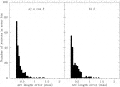 | FIG. 6.Histograms of source position errors for defining sources in (a) cos and (b) |
 | FIG. 7.Same as Fig. 6, but for candidate sources |
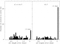 | FIG. 8.Same as Fig. 6, but for "other" sources |
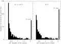 | FIG. 9.Same as Fig. 6, but for all sources |
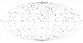 | FIG. 10.Distribution of defining sources on an Aitoff equal-area projection of the celestial sphere. The dotted line represents the Galactic equator. |
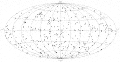 | FIG. 11.Same as Fig. 10, but for candidate sources |
 | FIG. 12.Same as Fig. 10, but for "other" sources |
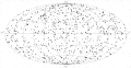 | FIG. 13.Same as Fig. 10, but for all sources |
3 Position tables and ancillary information can also be obtained from the IERS at http://hpiers.obspm.fr or from the National Earth Orientation Service at http://maia.usno.navy.mil.
According to resolution JD7 N.1, adopted by the 23d General Assembly of the IAU on 1997 August 20 in Kyoto, Japan, the ICRF described in this paper replaces the stellar FK5 catalog as the fundamental celestial reference frame as of 1998 January 1. The ICRS (Arias et al. 1995) is adopted as the celestial reference system, and the Hipparcos Catalogue (Kovalevsky et al. 1997) is its realization at optical wavelengths. As a consequence, the axes of the celestial reference system are no longer related to the equator or the ecliptic but are maintained from one realization to the next by the methods described in this paper.
The current realization of the ICRF condenses the information from a particular VLBI data set spanning a defined interval of time and reflects a certain state of VLBI analysis. As time progresses, we expect the realization of the ICRF to evolve, although changes in the ICRF catalog will be infrequent compared with past practice in VLBI astrometry.
There are several features that distinguish this type of realization from the conventional stellar catalogs that formerly defined the celestial reference frame. First, while we know the positional history of the sources, we cannot predict with absolute certainty what future observations will reveal. The current positions and velocities are a snapshot (or a movie), and continued observations are essential to maintain the viability and integrity of the ICRF. New sources must be observed to replenish and expand the list of candidates, and their positions in the ICRF must be determined. Current sources need to be observed periodically to track their behavior. Second, as observations accumulate, it should be possible to move candidate sources up or down the scale of usefulness. However, it is conceivable, perhaps even probable, that an identical categorization of sources from an analysis using twice as long a time interval would show sources changing categories in unpredictable ways. For example, there is no physical reason to expect that linear position changes can continue indefinitely. Such motion would call into question the fundamental basis of the extragalactic frame, i.e., the great distances of the objects. Directed position changes should cease at some time. Conversely, a source now stationary could start apparent motion. Only future experiments and data analysis will show. The problem of position variation may be solved in the future if the application of source structure information permits the identification and use of truly kinematically stable points in the sky. Progress toward this goal has been made in the case of the core-jet source 3C 273 (1226+023). Charlot (1994) has shown that modeling the source structure effects of this source significantly improves the positional stability. This remains to be demonstrated for other sources. Unlike stellar catalogs, however, the original VLBI observations should always be accessible for improved analysis de novo.
Despite the burden of maintenance, the ICRF realized by VLBI astrometry is a great step forward. Compared with stellar realizations, it is intrinsically simpler, much more accurate, more stable, and less susceptible to systematic deformations. It will serve the purposes of astronomy and geophysics well.
VLBI is a collaborative and cooperative activity. Without the sustained efforts of many individuals and institutions located around the world over an extended period of time, the new celestial reference frame would not have been possible. We wish to recognize and thank the designers and fabricators of VLBI instrumentation, from masers to receivers to data acquisition terminals to correlators; the operating personnel at observatories and correlator facilities; the schedule makers and coordinators; the generations of model builders, software developers, and analysts; and the farsighted visionaries and funding agencies who thought the job could be done.
.
1994, in VLBI Technology: Progress and Future Observational
Possibilities, ed. T. Sasao, S. Manabe, O. Kameya, & M. Inoue
(Tokyo: Terra Sci.), 287 First citation in article,
ed. 1995, Earth Orientation, Reference Frames and Atmospheric
Excitation Functions Submitted for the 1994 IERS Annual Report (IERS
Tech. Note 19) (Paris: Obs. Paris) First citation in article, ed. 1996, IERS Conventions (1996) (IERS Tech. Note 21) (Paris: Obs. Paris) First citation in articleFinal Report of the Crustal Dynamics Project VLBI Geodetic Results, 19791991 (NASA Tech. Memo. 104572) (Greenbelt, MD: GSFC) First citation in article